Overview of this years tasks
In this phase Anne would like our help to generate the inp files. There will be a lot of inp files generated. We are calling this an ensemble of INP files. These files will contain different plumes, rainfall, and possible sensors locations. They would all need to be in the same network.
The inp file needs to be modified programmatically so that the network is not changed but various sections of the network are changed.
Sensor Locations are not part of the INP file. What we will have to do for this section is get all the subcatchments that can be used as sensor locations and create possible sensor files. This is part of what chama finding the best sensors out of a list of possible sensors but we feed it possible sensors. If this process is taking a "NEW" network and getting it ready with 1000 inp files then part of that would be to give multiple subsets of sensor locations that chama can chew through. The reason that we would not give all locations as possible sensor locations is that will make chama run much longer this is why we have been using a subset in the first place.
There also needs to be management of all of these files. A SQL Database will be used to store this data. We are trying to make this database easy to manage and easy to understand by someone with very little database experience. So it needs to be clean and easy to use.
Tasks List
- Where can we get rainfall data for the rainfall.dat file. (EPA SWC)
- Setting up the rainfall in a separate file. (We do this with SWC)
- Setting up the rainfall with multiple gages in separate files.
- Can we have rainfall from multiple gages in a single rainfall.dat file?
- would it be easier to just have multiple files.
- Running the rainfall does it need to be in sync with the time period we have?
- If we have years in the rainfall.dat file does swmm just take the correct rainfall?
- I assume it does but that might need to be verified.
- If we have years in the rainfall.dat file does swmm just take the correct rainfall?
- Are we going to need to create rainfall.dat files for Light rainfall, Moderate Rainfall, and Heavy rainfall?
- Can we have rainfall from multiple gages in a single rainfall.dat file?
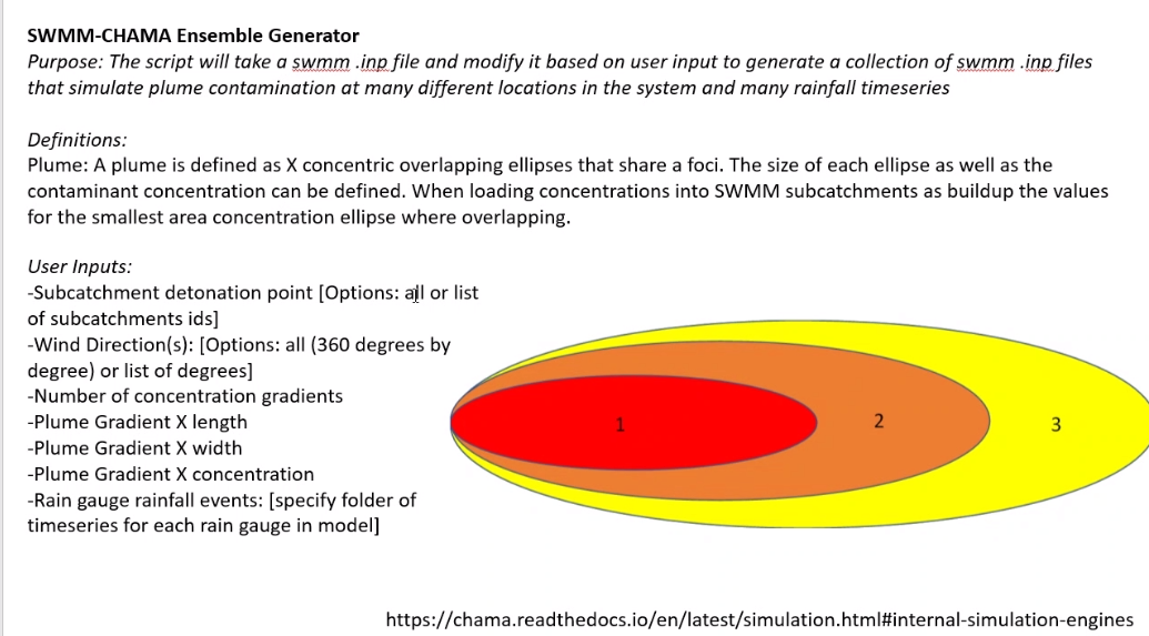
- How are we going to decide on plumes.
- Is the user going to select each subcatchment?
- Is the user going to pick a single point and from X far out that is the plume?
- Where are we downgrading the concentration.
- What are the levels of concentration.
- Are we always going to have the same concentration.
- How are we going to get wind direction (Is this arbitrarily or are we looking at actual storms)
- How is the current database set up
- Is it easy to use.
- Should we have a different database for just managing the input files. (inp files, rainfall data, sensor locations)
- The files will not be stored in the database they will need to be in a file structure that file structure needs to be easy to navigate and it needs to reflect the database structure.
Rainfall
- Hourly rainfall.dat files are available in the Banklick area for the years 1990-2019. There are 5 rain gages. KCVG at the airport is the one closet to the area. Even that is not in the same county. It is the raingage we would use however. The next closet is in Cincinnati Ohio.
- How are we
The changes to the INP file will be to the rainfall section for this issue.
Plumes
We have 2 banklick plumes ready. So we know the style that is expected. We will need to write up a way to automate the process or allow the user to select the areas easily. This is where I forsee the need to view the network on a map. This is also where we will need to make the decisions on how the user selects the plume.
Wind Direction
Database and file Storage
Show a banklick ERD.